Road Trip! Kentucky - Louisville and Perryville Battlefield!
So this is the THIRD blog post I’ve written about this trip. The first one was the recap of Imaging USA for our community at Frameable Faces Photography - our photography studio - and the main purpose of the trip. Imaging USA is a fantastic national photography convention through the PPA (Professional Photographers of America). The second was here on M10 Social focusing on the general business and marketing lessons I came away from the convention with.

Now it’s time to focus on the history - you KNOW I’ll never take a roadie without hitting some history, and there is plenty of that in the Bluegrass State! As a tip I recommend that this post is either viewed on a desktop / laptop or if you are viewing on a smaller device like a smartphone you’ll be able to view the photos individually better if you scroll and view horizontally (landscape).
Here’s the route we took for the trip:

Louisville
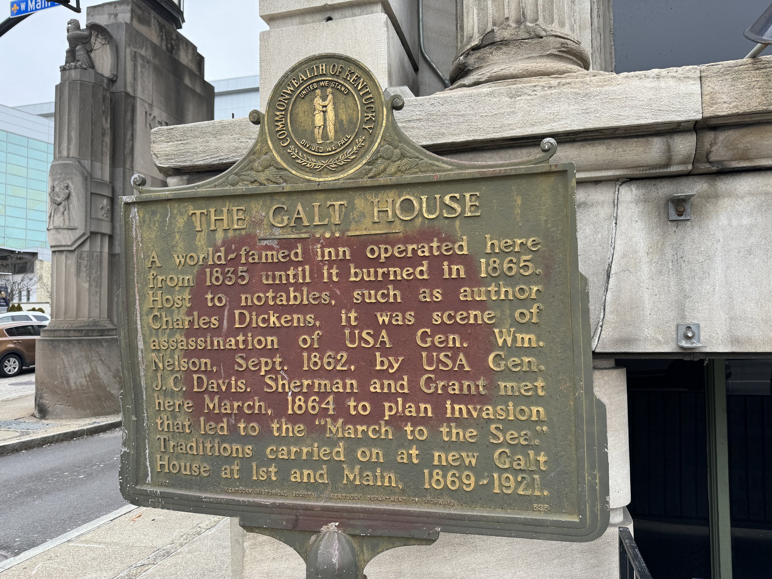
We’ll start with Louisville where right around the corner from the Kentucky International Covention Center is the site where the Galt House stood. I originally thought the famous hotel stood on the site of the current Galt House which is a huge luxury hotel right on the Ohio River but it’s actually a couple blocks away at the Northeast corner of 2nd and Main Streets. There is a historical marker there that mentions the since-debunked (seemingly) claim that Grant and Sherman met at the Galt House to plan their 1864 invasion of the South.
What DID happen at the Galt House is one of the more infamous incidents of the Civil War - the murder of U.S. Major General General William “Bull” Nelson by fellow U.S. General Jefferson C. Davis (not the rebel president). Nelson was a huge man at about 6’4” 300 lbs, a friend of President Lincoln, and we first encountered him on this blog at the Battle of Richmond, KY where he was wounded in the U.S. defeat there. He was a polarizing figure - he actually accomplished a lot in the first year of the war helping to turn the tide at the Battle of Shiloh, and recruiting many soldiers to defend the U.S. at Camp Dick Robinson at Lincoln’s request. But he was really rough - a bit of a bully and his interpersonal skills (or lack thereof) ultimately got him killed right in the lobby of the Galt House in front of several bystanders. Camp Nelson National Monument is named for him - a U.S. depot during the Civil War and site of the Civil War recruitment of over 10,000 African American soldiers who fought for the U.S. not far from the original Camp Dick Robinson.


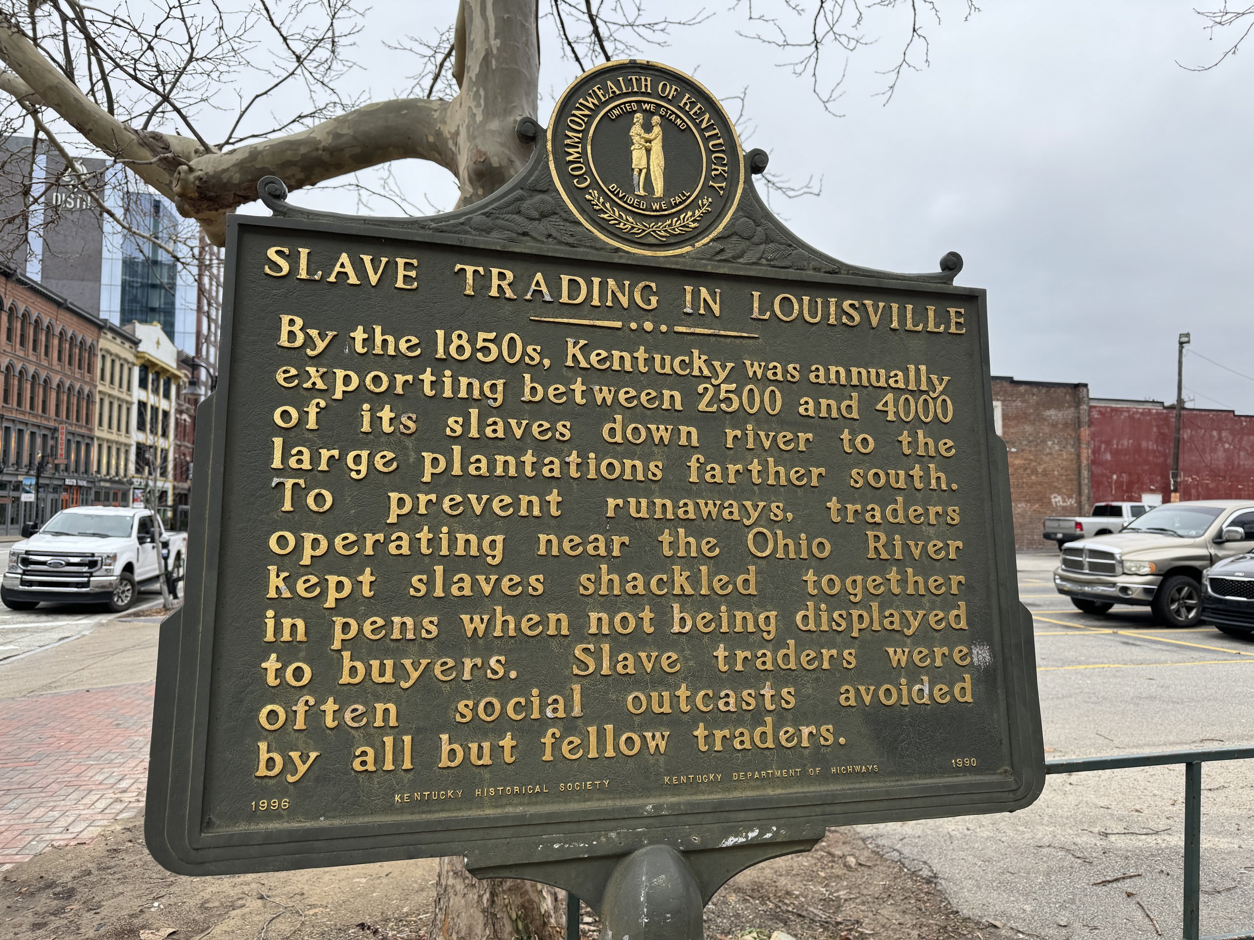
Historical Markers About the Slave Trade in Louisville
No Civil War battles were fought in Louisville. And while Kentucky was a neutral state there was a lot of slavery there and Louisville was an active center of the slave trade for years. Kentucky was never seriously threatened by Confederate armies after the battle of Perryville in1862 and more soldiers fought for the U.S. Army than for the rebels in the war, but I did read that Louisville has a significant Lost Cause history as many rebels settled in the city after the war. Louisville’s history of involvement with slavery is acknowledged at the least with a couple of markers I photographed, but I find the first one to be interesting in that they took pains to say slave traders were “often social outcasts avoided by all but fellow traders”. Hmmm…. are we buying that? Like hey - there were slave traders here yeah, but at least like, no one liked them.
Don’t get me wrong - my objective is NOT to take shots at Louisville. We had a fine time there - it’s a cool city! Just some observations in the context of Civil War history really that the country continues to grapple with not just in Louisville. These markers and the Galt House are really all of the history I had time to explore downtown as I was tied up with the convention during our trip. As for Thornton and Lucie Blackburn and the Blackburn Riots of 1833 I have to say I’m disappointed that I never learned about this growing up in Metro Detroit. It’s a fascinating story and the historical marker below stands right by the current Galt House hotel at 4th and Main where Thornton Blackburn was hired out as the marker says. Here’s more on the Blackburn’s story by Ken Coleman for Michigan Advance. I had to travel all the way to Louisville and stumble upon a historical marker to learn about this?

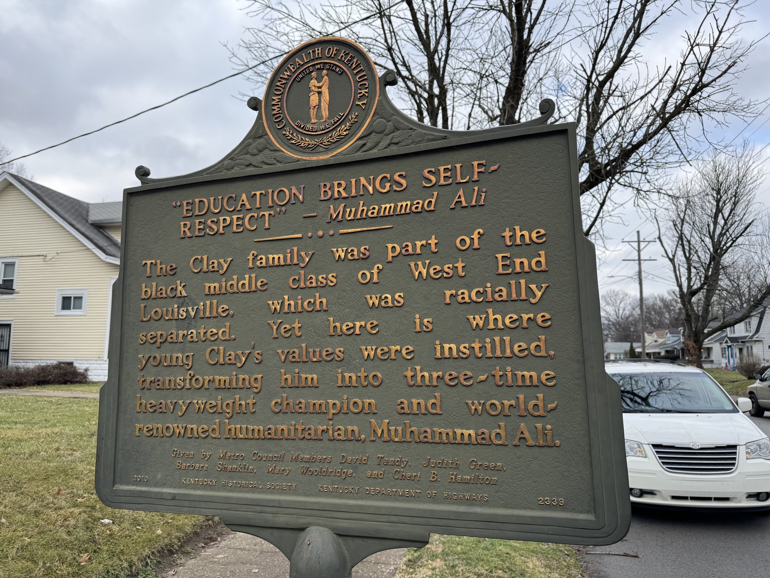
Muhammad Ali Boyhood Home
This was cool. Just a small pink house on a residential block in Louisville. The house next door apparently is a gift shop but it didn’t appear open and so we just pulled up, I took a couple photos, imagined young Cassius’s life on this street and we headed out to try to get to Perryville in time to explore the battlefield before making the drive home to Michigan.


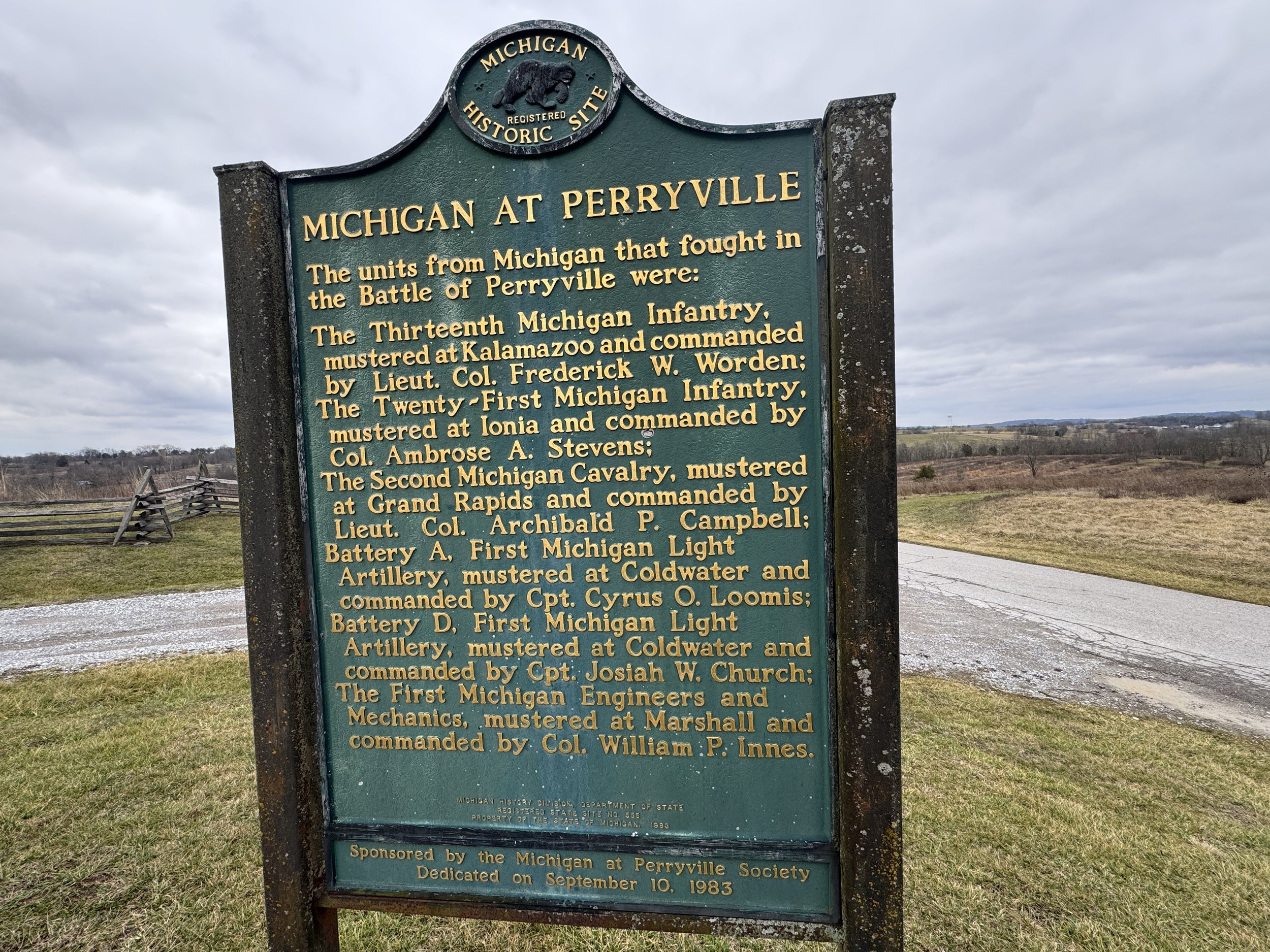
Perryville Battlefield
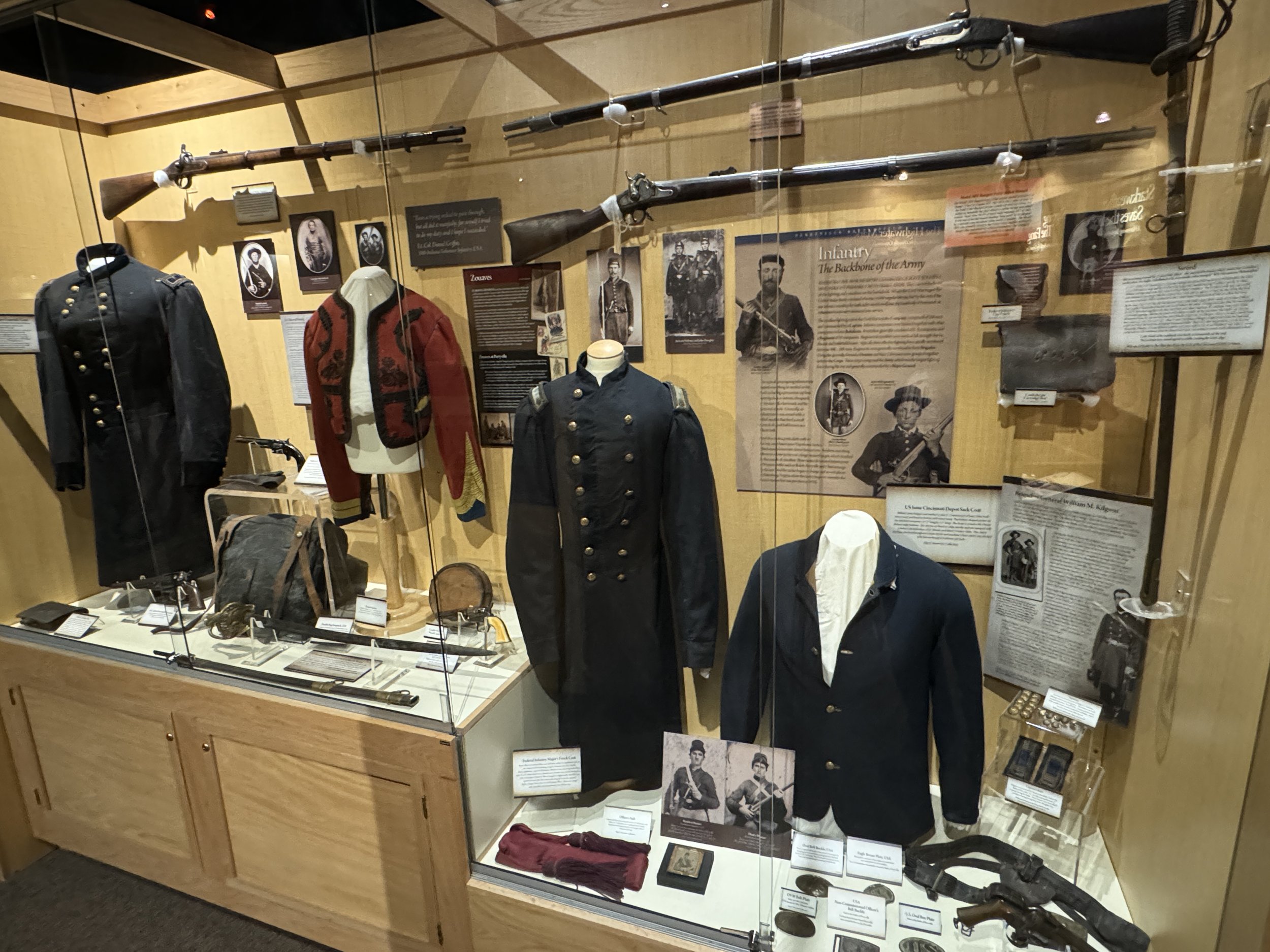
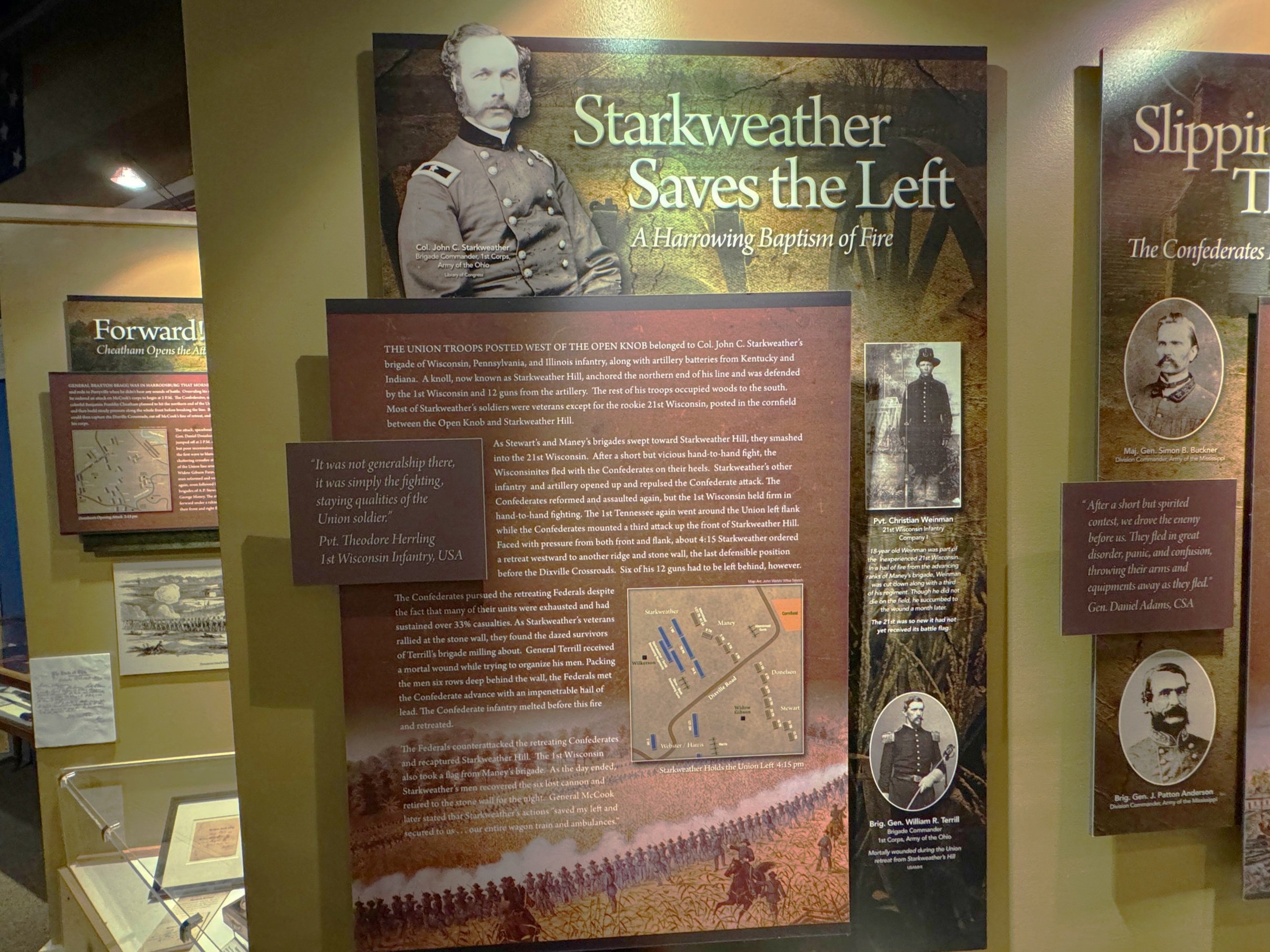
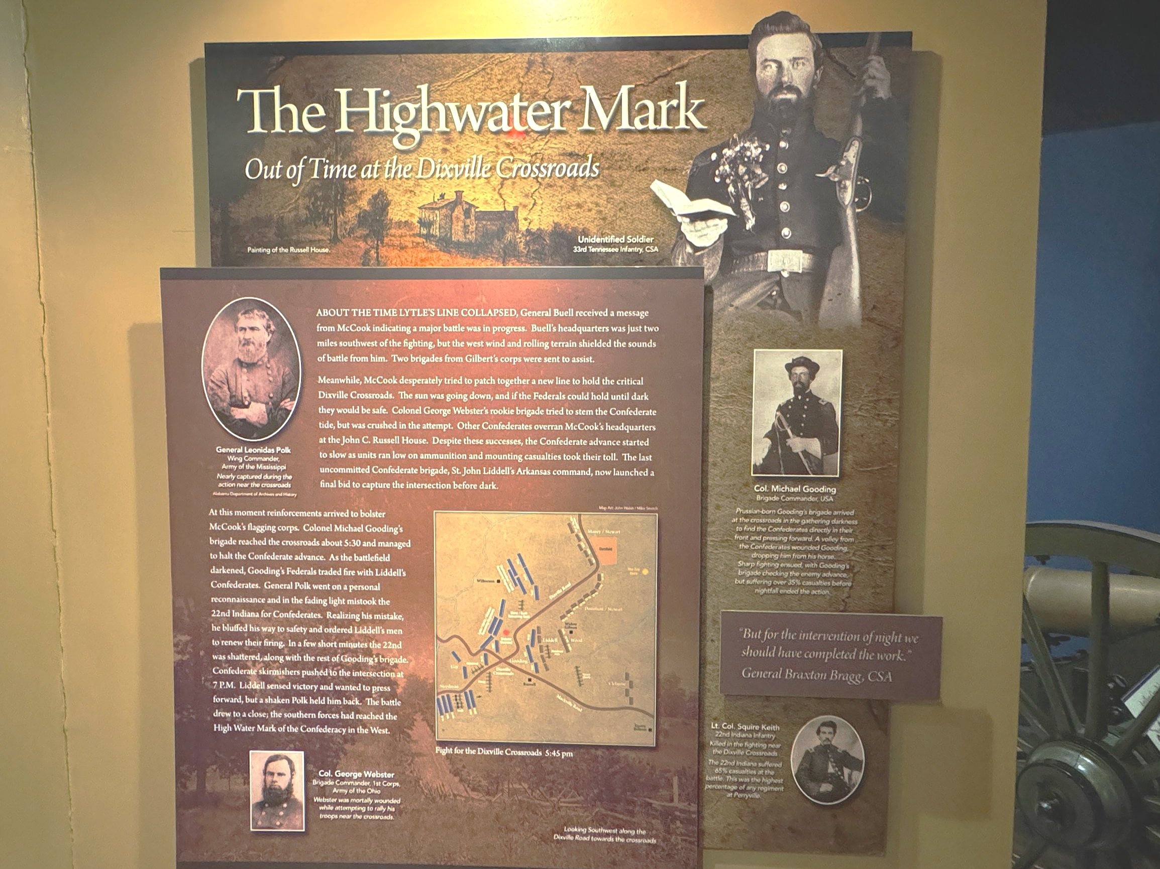
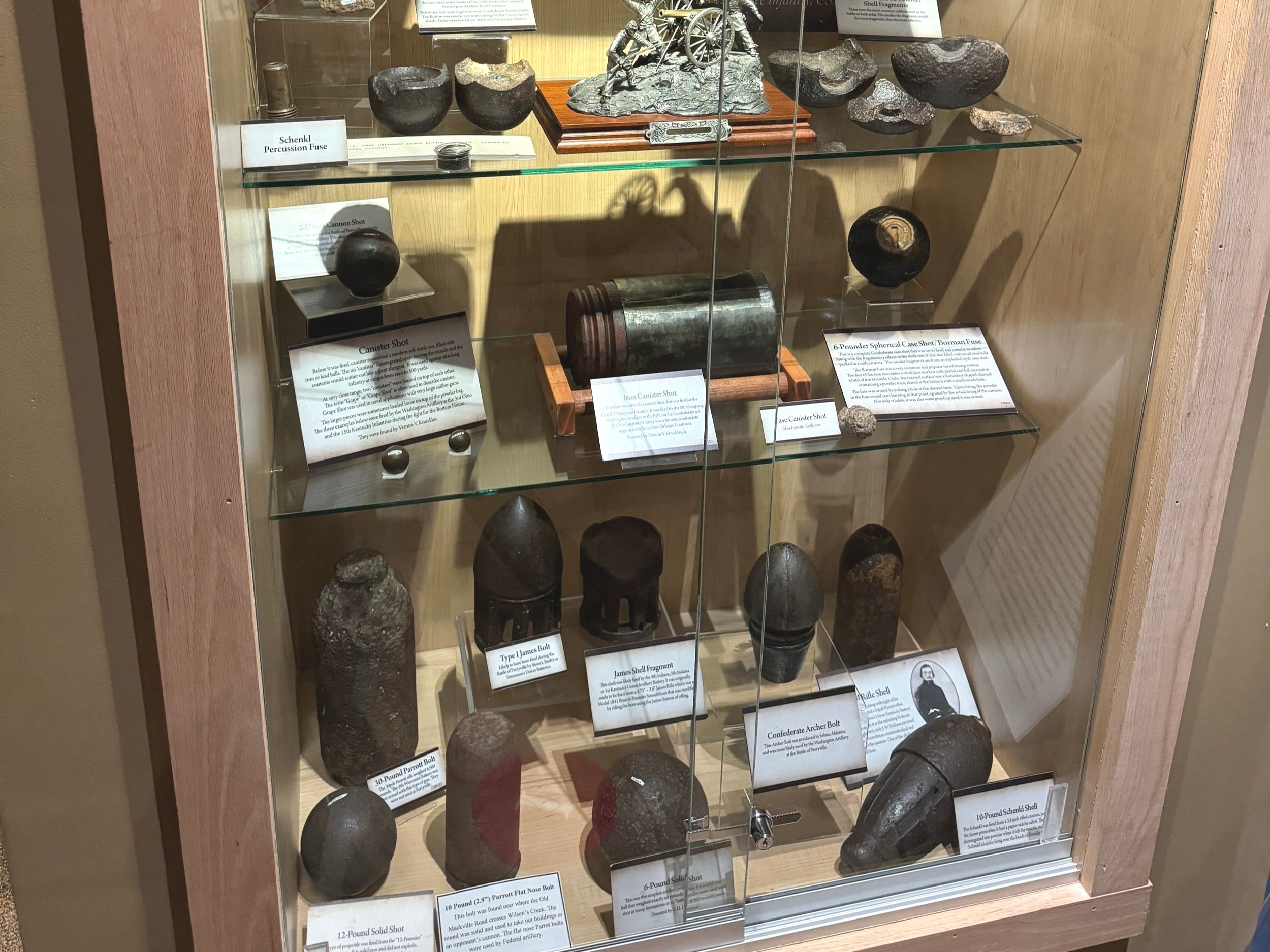
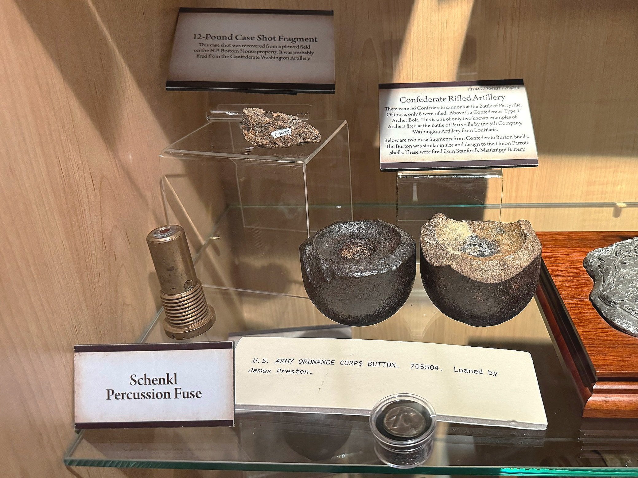
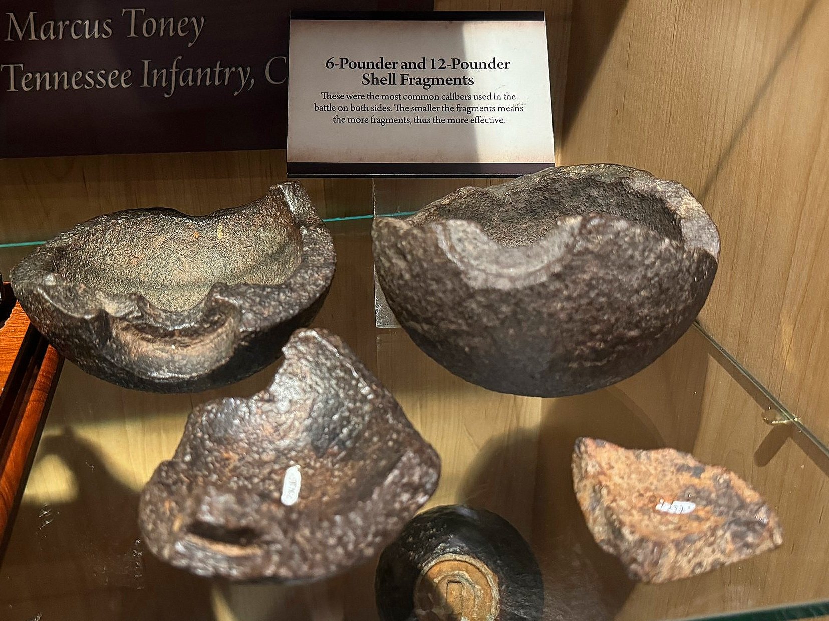
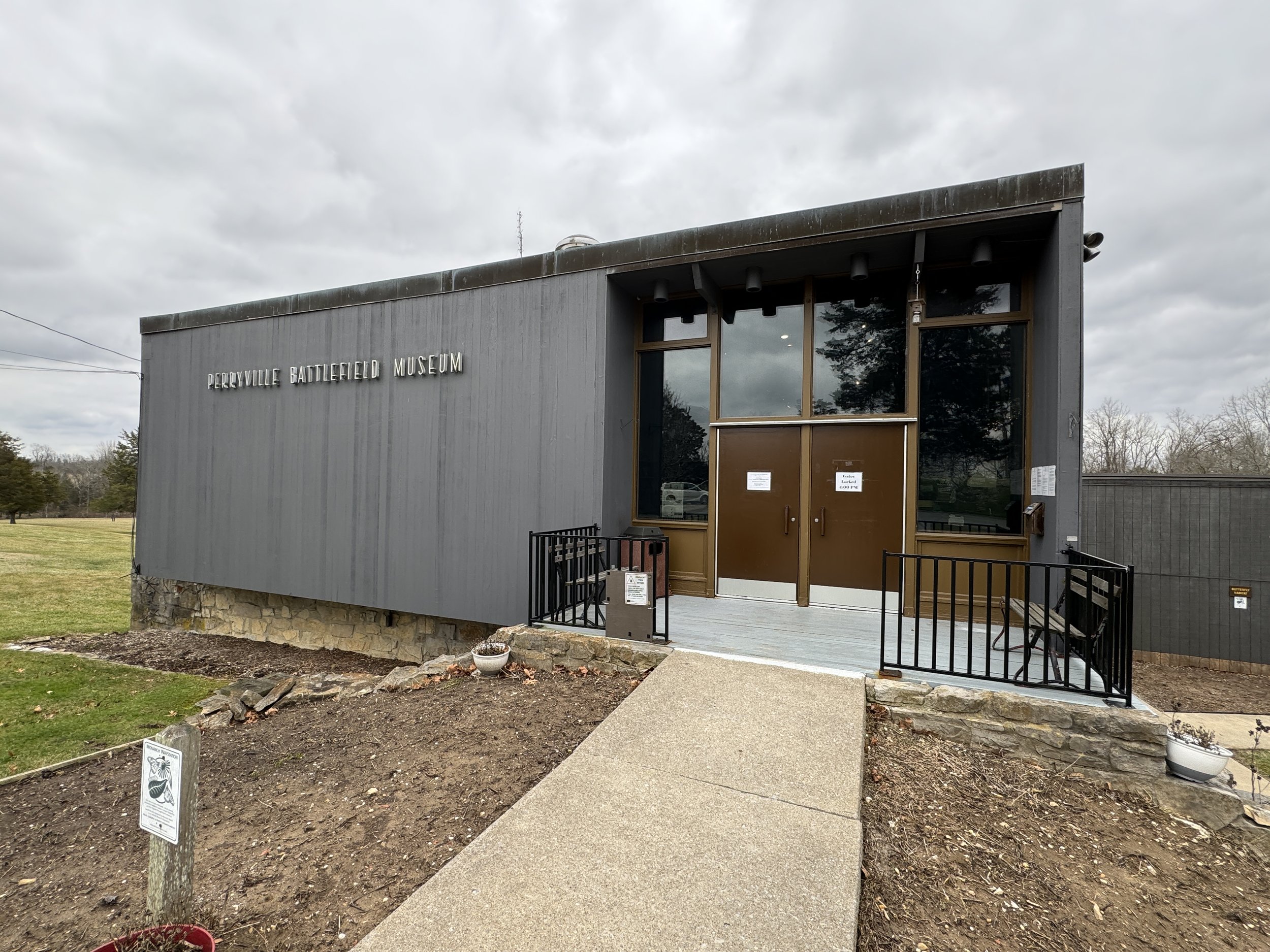
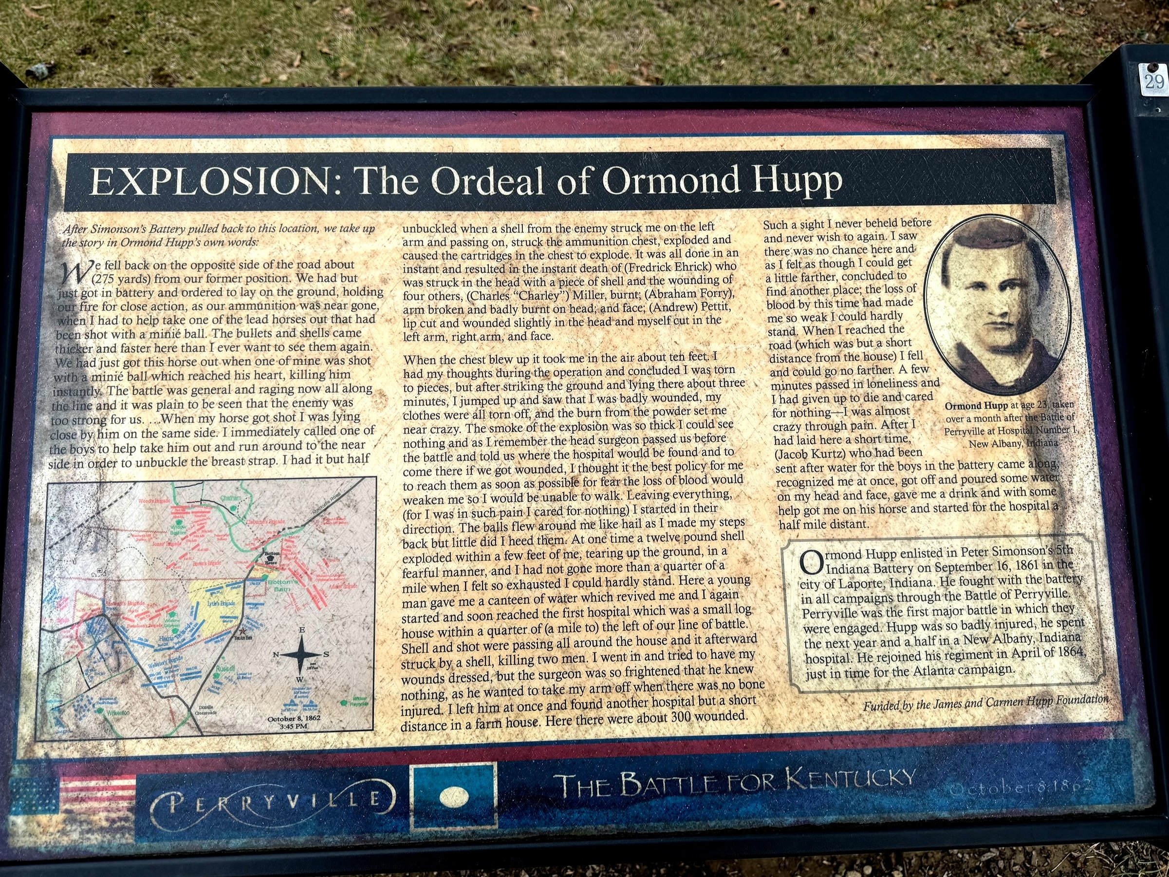
Perryville had been on my list of battles to visit for a long long time and this was finally my opportunity. It’s the closest major Civil War battlefield to where I live but it’s not on the way TO anywhere… and I’ve never planned a trip straight to Perryville. I had always heard it was a well preserved gem and it absolutely is. We spent 3 hours there which is enough to cover the battlefield, just not at the level of detail I like. But it’s a really well done state battlefield park and a lot of land has been added by preservation efforts led by the American Battlefield Trust as usual. The gentleman at the visitor’s center said they’ll be adding more interpretive markers to some of the areas that they just received into the park which I always find exciting. Let’s start at the museum which is loaded with artifacts from the battle - informative panels telling the story of the battle, tons of weaponry and uniforms including an impressive artillery collection of shell and canister. Not sure you’ll be able to read a lot of what’s there but I’m just including a bunch - worth making the time to hang there for a bit. There’s a complete amputation kit as well which is always fascinating and a little rough to look at…
This battle was more or less a draw. Tactically you could make the case that it was a Confederate victory since they pressed the action and mostly drove the Army of the Ohio across the battlefield, but the Confederates were forced to retreat out of Kentucky as a result and they never threatened Kentucky again. U.S. Major General Don Carlos Buell commanded the Army of the Ohio (later renamed the Army of the Cumberland) and had about 55,000 men in the area. Confederate Major General Braxton Bragg (not a good general or regarded by many as a good man either) commanded the Army of the Mississippi (later renamed the Army of the Tennessee) and only had about 16,800 men at Perryville. However Buell only had 20,000 engaged - he was several miles away but the nature of the terrain muffled the sound of battle and Buell didn’t even know there was a significant battle going on for most of the day. He finally started to mobilize reinforcements by the end of the day, and when Bragg realized how badly outnumbered they really were he began to withdraw after midnight.


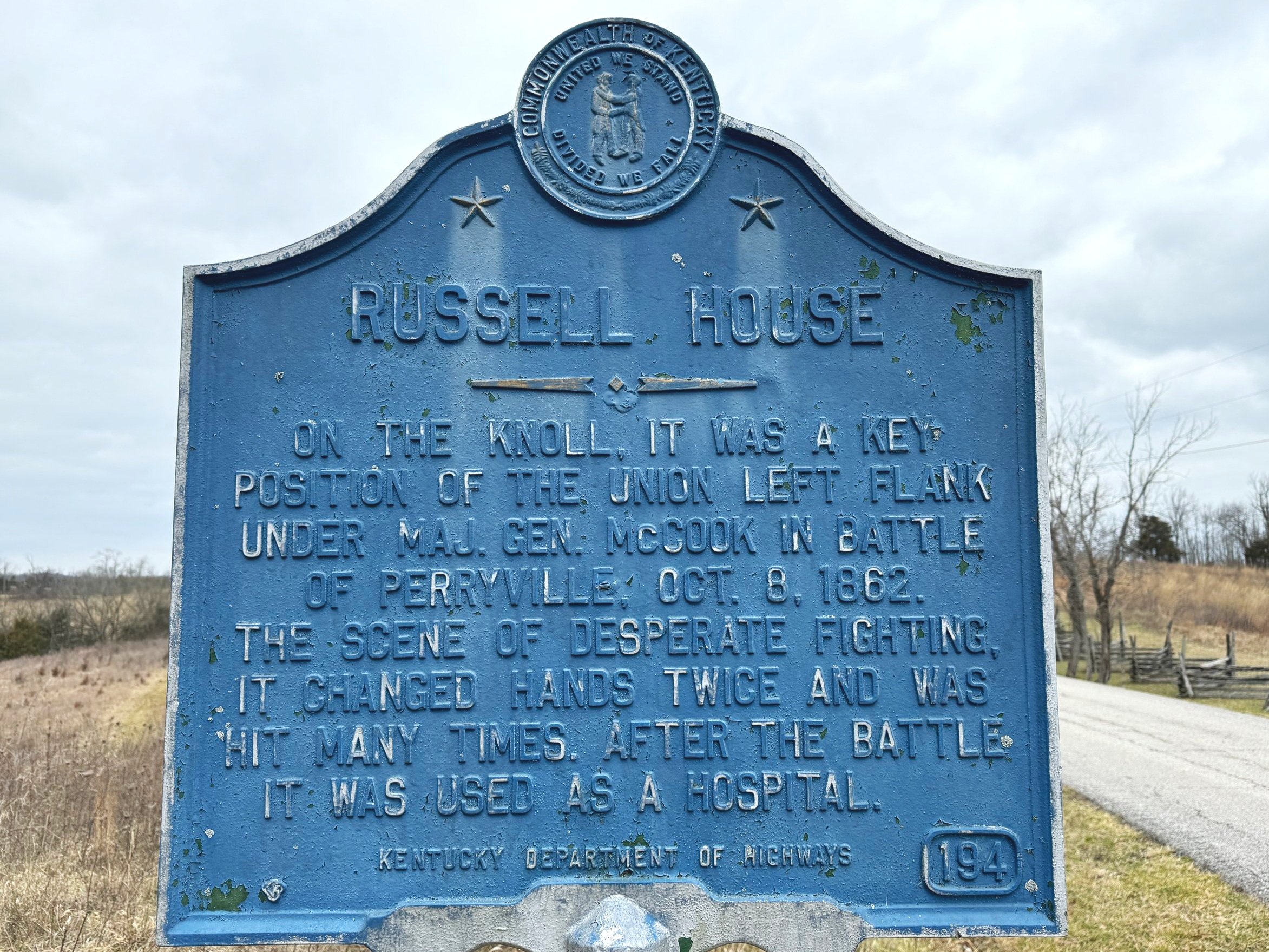
I also want to call attention to the panel called “Kentucky A Divided Land” - stories like these highlight some of the complicated layers of the Civil War. Two generals. Both fighting for Kentucky. One for the U.S. Army (Brigadier General Lovell H. Rousseau) and one for the Confederacy - Major General Simon Bolivar Buckner. Buckner’s story is particularly interesting. He fought for the U.S. in the Mexican War and was elected governor of Kentucky years after the Civil War. He eventually served as a pallbearer for his old friend from West Point and the Mexican War, President Ulysses S. Grant - even paying for his funeral. Buckner gave Grant money after the Mexican War when Grant was broke and living in New York and he surrendered a Confederate army to Grant after the fall of Fort Donelson when Grant said only “unconditional surrender” would be accepted - but Grant offered to loan Buckner some money to help him through his impending imprisonment which lasted for 5 months. Buckner’s son was the highest ranking American general to die in WWII on Okinawa.
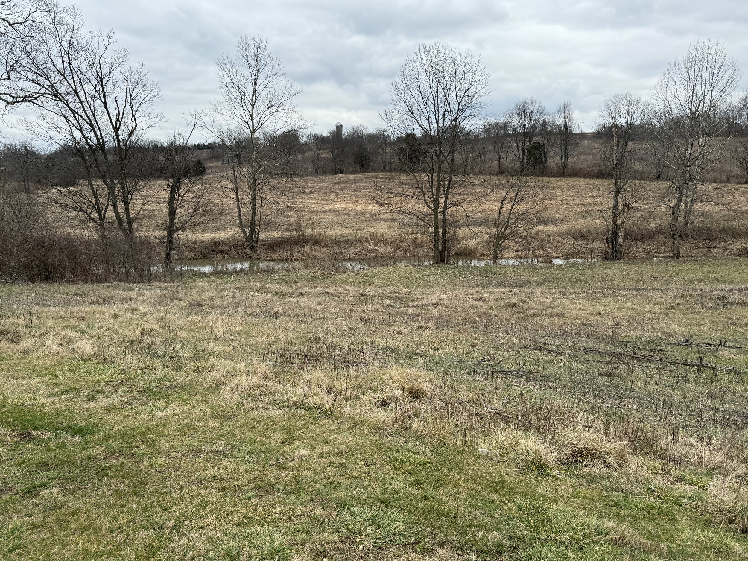
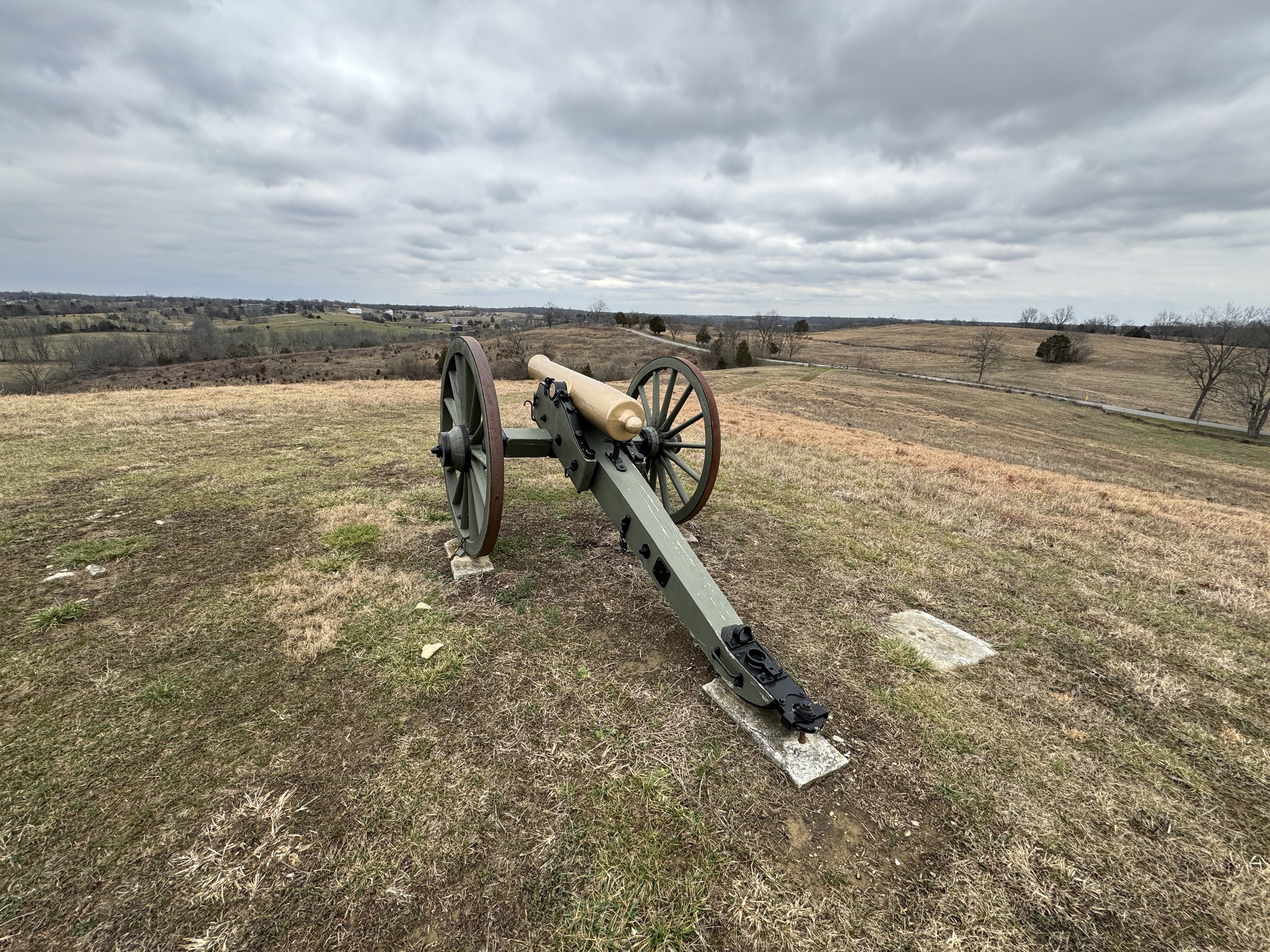
The Battlefield
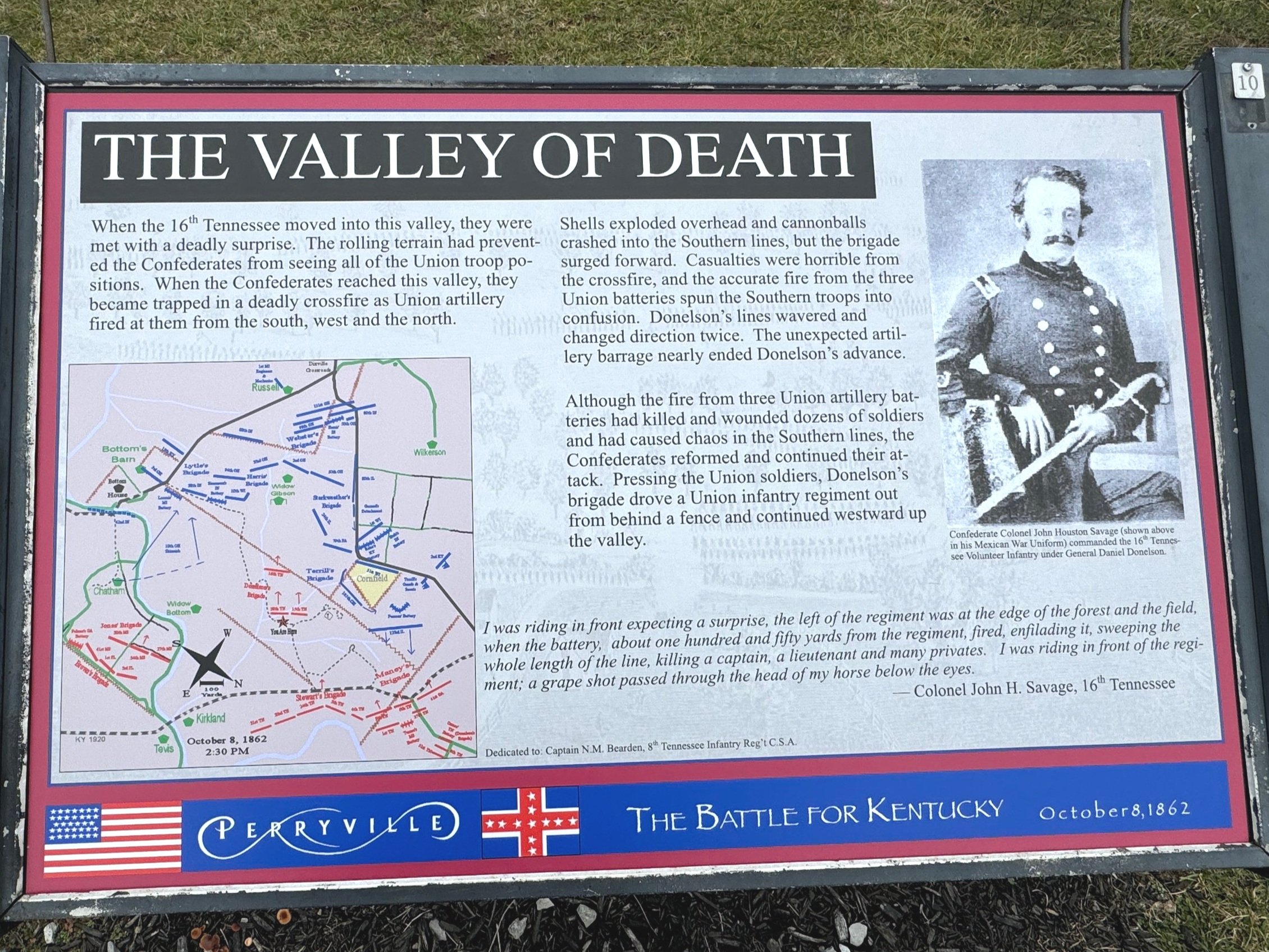
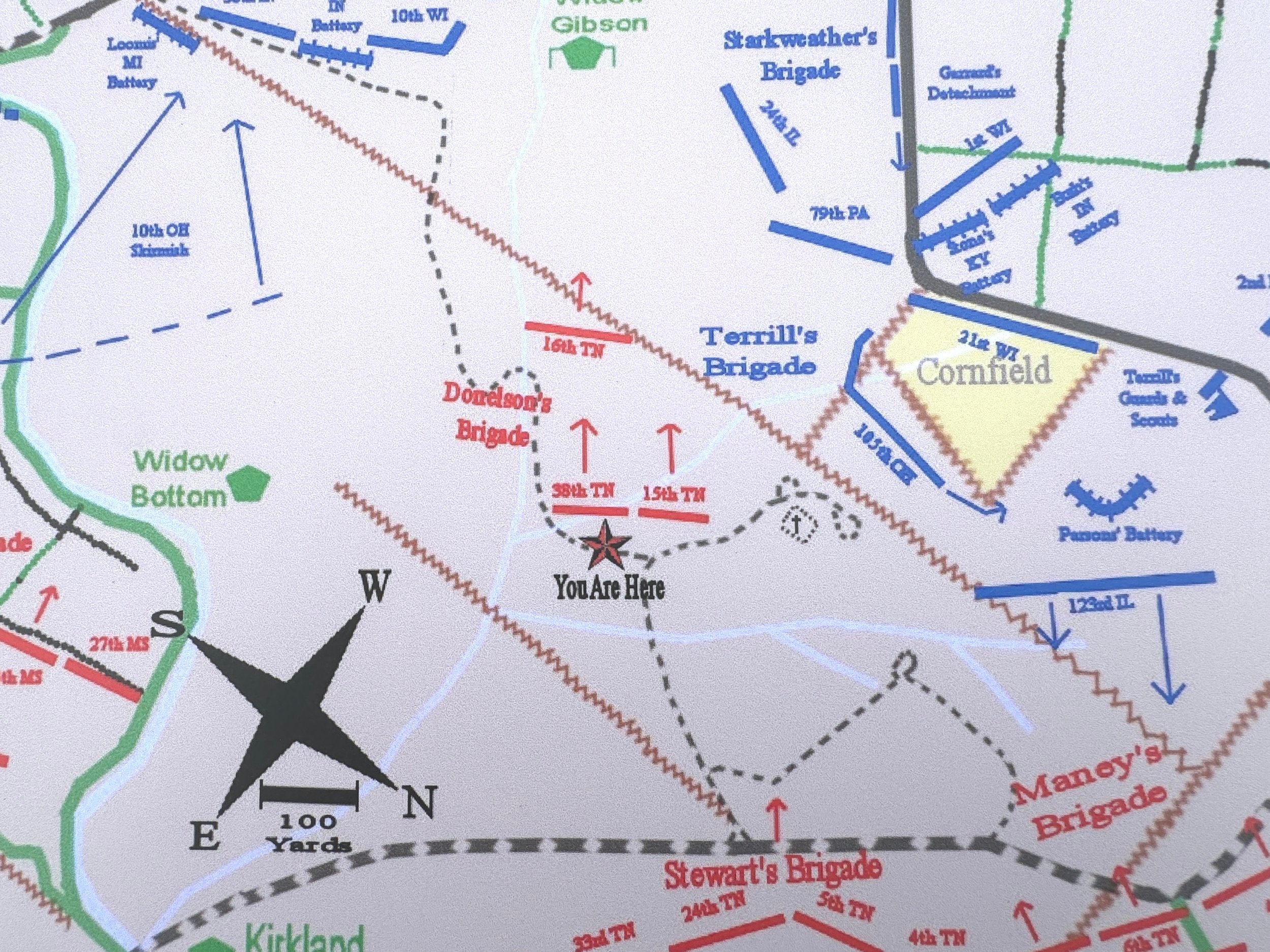
We did a driving tour and then I did a hiking loop - the driving tour is in blue and the main hiking loop of stops 1-10 was the one I did - I didn’t make it to the Slaughter Pen or Final Line trails.

You can see how the trails correspond to the action of the battle with this map below that represents the situation at 3:45 PM on October 8th, 1862. There are maps for each stage at the Wiki page or at Hal Jesperson’s website which is outstanding. You can also see an INCREDIBLE map that represents the land that has been preserved just since 1987 by the state of Kentucky and the American Battlefield Trust here.

Map by Hal Jespersen, www.cwmaps.com
The Driving Trail
First we’ll trace the driving trail in my photos and then we’ll hit the hiking trail. The first stop is the Confederate cemetery that has around 200 unknown soliders buried in a mass grave and there is a big monument there that was erected in 1902. There is also a monument just next to this spot that was erected in1928 to honor the U.S. soldiers who fell as well, and then in front of both monuments there is a tablet on the ground that was laid on the 150th anniversary of the battle in 2012.


Wow… If you have questions about any of the positions feel free to comment but also visit the links and refer to the maps to help you.
Walking Loop
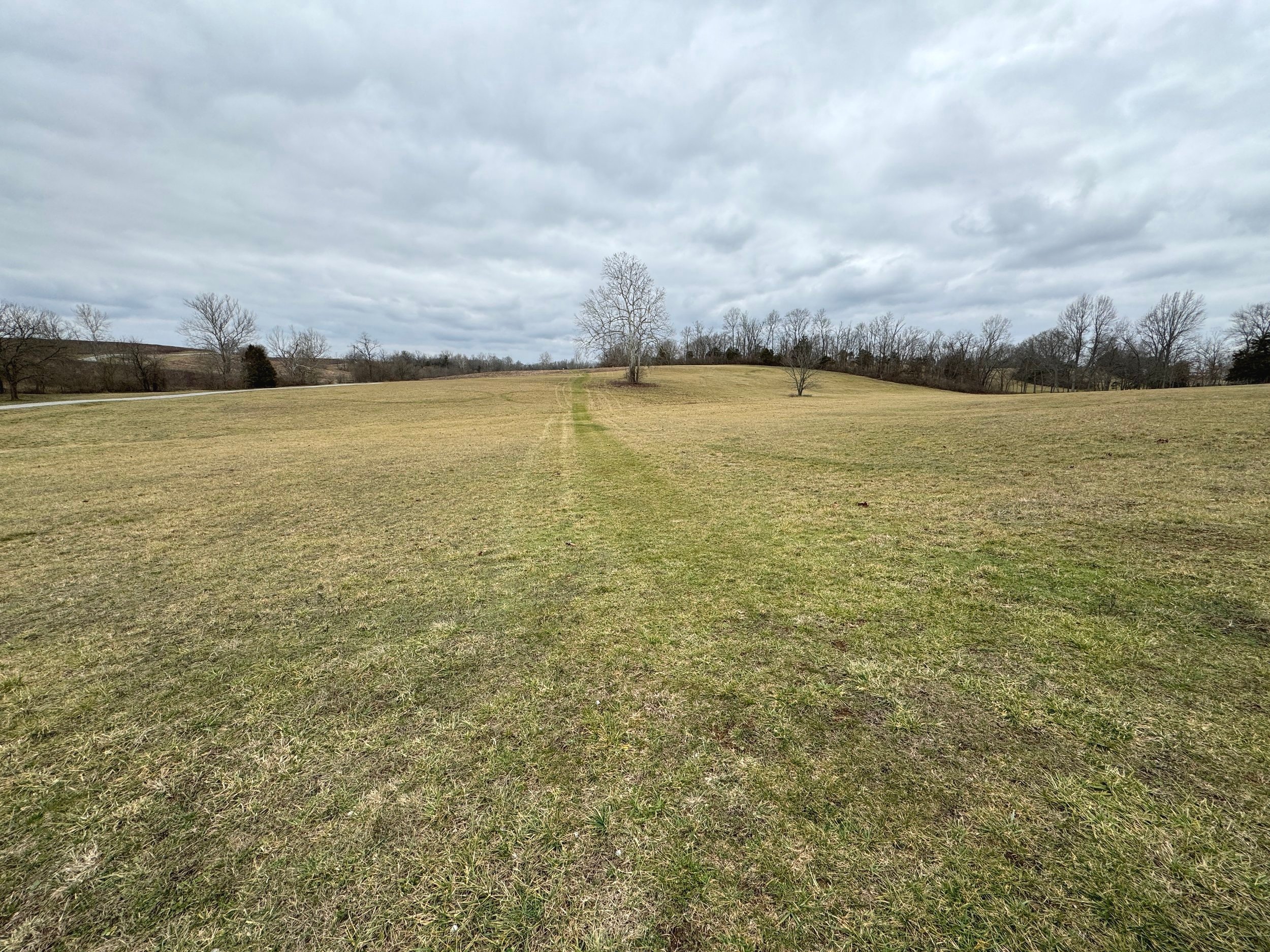
The next phase for me was to walk the battlefield on the trail loop which was pretty cool - added plenty to the understanding of the battle with multiple panels describing the action. Some battlefields it just depends and I was happy that the trail added plenty to the drive. Granted even being able to walk parts of a battlefield can bring plenty of understanding to the battle even when it’s not fully interpreted with signage if you have maps and/or apps or audio tours. Pickett’s Mill outside of Atlanta comes to mind as a battlefield that even with a visitor’s center there is still not a sign, not a monument - nothing on the field itself other than little wooden markers with a number on them to let you know where you are, and it’s wooded so you wouldn’t really have a clue visually. Anyway back to the battle…
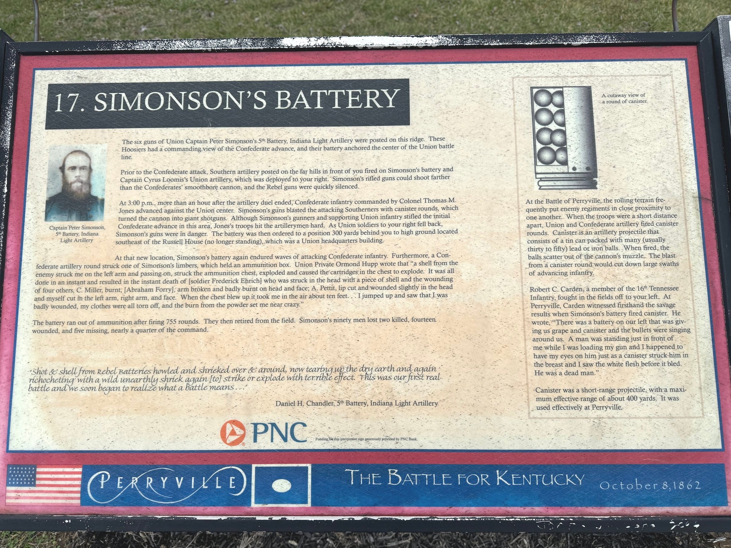
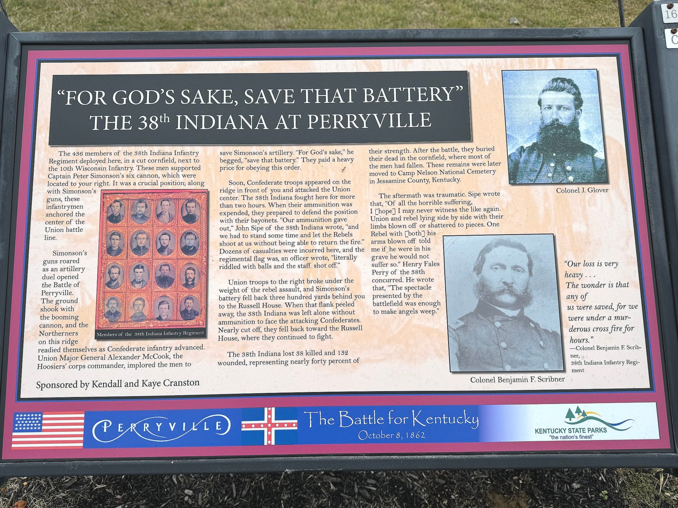
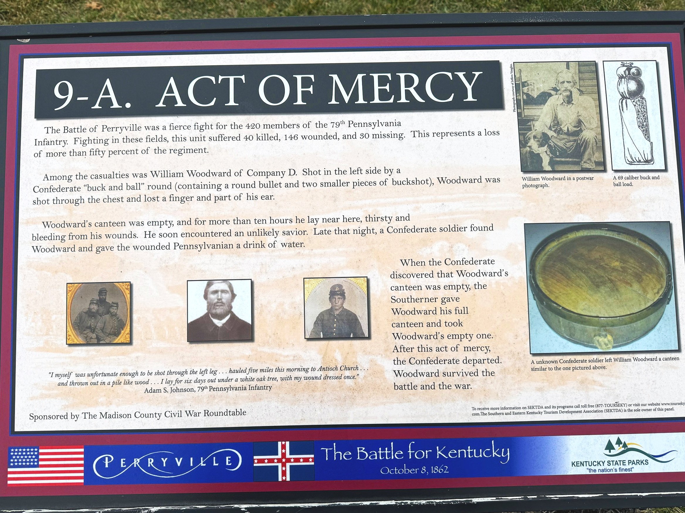
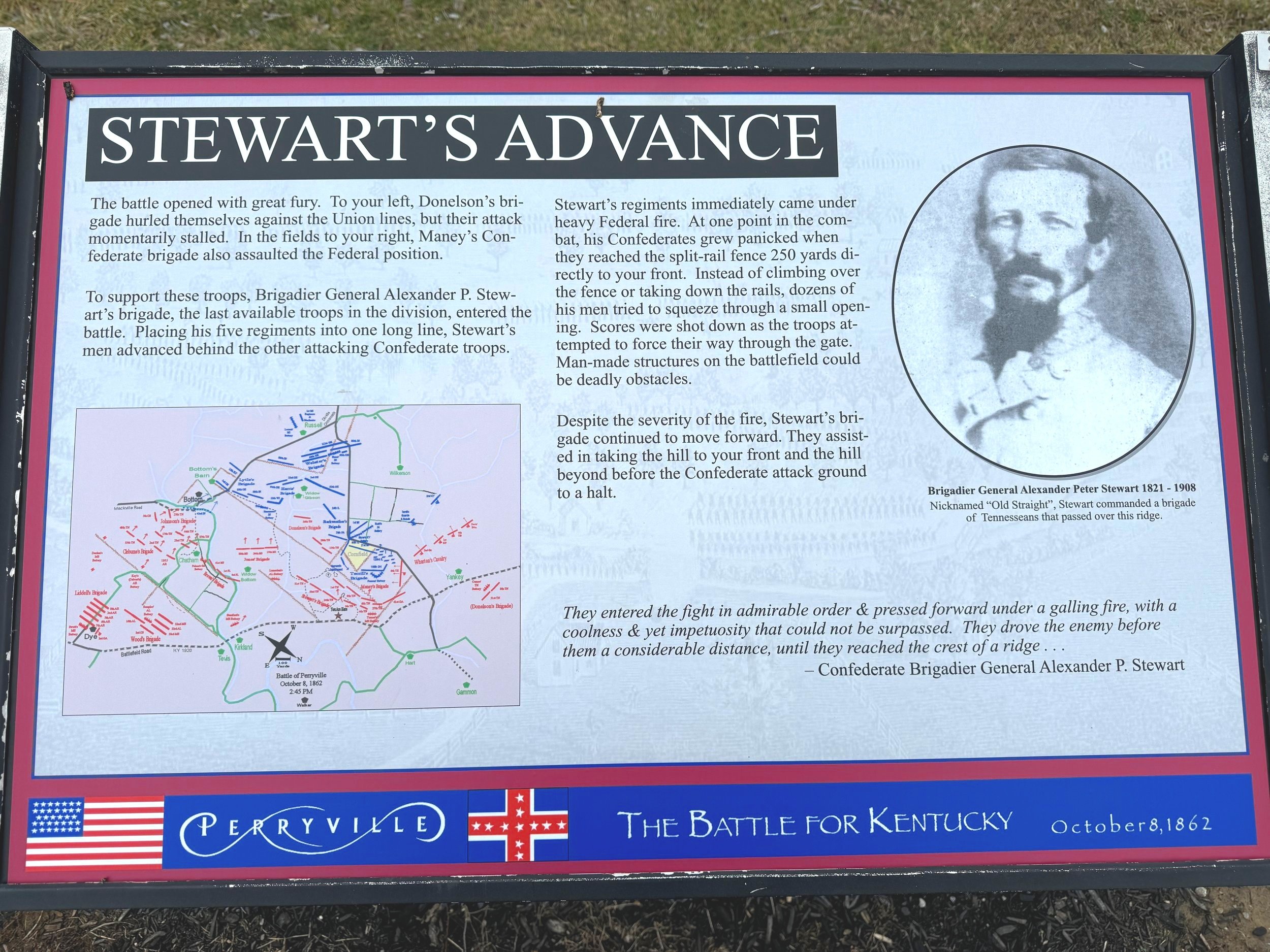
I actually walked the trail in reverse going clockwise from stop 1 to stop 10 instead of counterclockwise from 1 to 2. The walking trail goes the opposite way of the driving trail which is why I think I was a little confused. It seems to me that it helps to follow the battle logically starting with the Confederate positions that launched the attack and then looping around to the U.S. defense. But once again you can follow the photos with the trail map above, and I would encourage you to view this on a desktop, open a second window and use the Hal Jesperson maps of the battle to really get an understanding. You can also see and read the panels I selected to share here a little better on a bigger screen. I already covered stops 10 and 7 on the driving tour and I’m presenting the photos from the walking trail in the following order even though it’s not the way I walked it: 1) The Opening Attack launched by Donelson’s rebels 9) Bloodbath at the Crib 8) Act Of Mercy. Then at this point we shift back to following the rebel right advance from 2) Stewart’s Advance 3) Maney’s Attack 4) Assault on Parson’s Ridge 5) Defense of Parson’s Ridge and 6) The Cornfield. So basically we follow Donelson’s opening attack on the Confederate left and then we come back and follow Stewart and Maney’s opening attack on the Confederate right.
Interesting tidbit here - Confederate Brigadier General Daniel S. Donelson who led the opening attack was raised by his Aunt Rachel Donelson and her husband Andrew Jackson after his father died when he was 5 and his mother remarried. Yes - that Andrew Jackson. He was serving as the speaker of the Tennessee house when the war broke out and Fort Donelson (which Grant captured 8 months before the Perryville battle) was named for him. Donelson later died in the war in April 1863 of chronic diarrhea. Yikes. I’m not interested enough in Donelson to read a full biography of him (at least one has been written that I can find), but of all the intertwined stories of Americans, split loyalties and traitors I find his to be one of the more intriguing from the standpoint that basically his adopted father was ready to put down a potential South Carolina secession by force as President during the nullification crisis in 1833, and that President’s adopted nephew took up arms against the U.S. (NOT a given in the very divided state of Tennessee) and died in the war crapping himself to death. The irony….


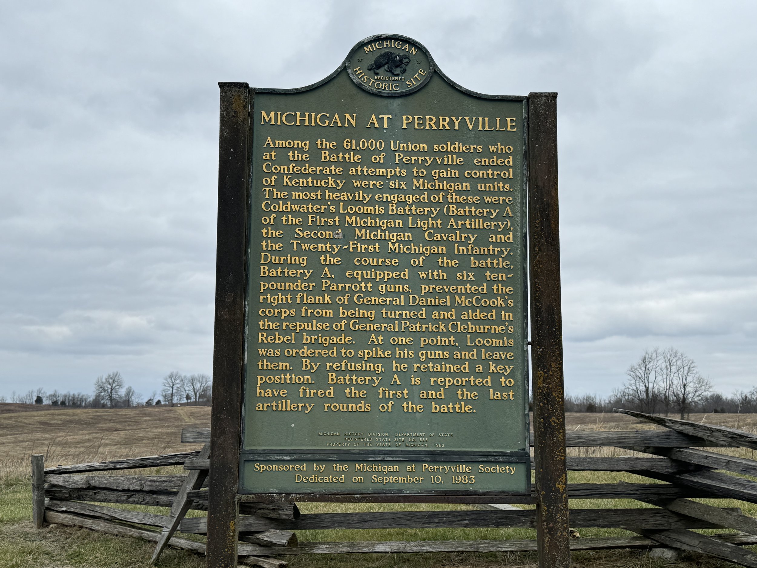
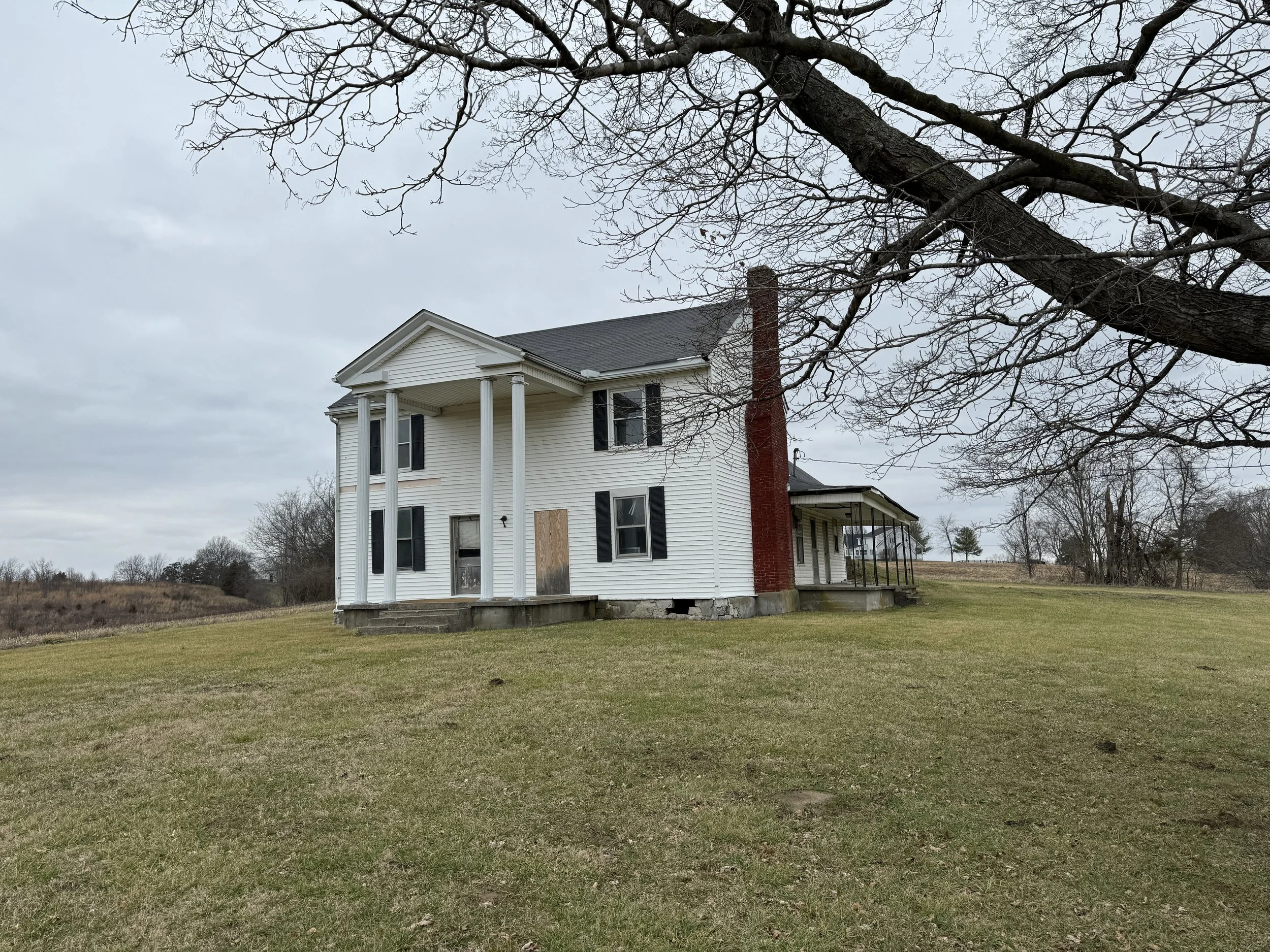
Last stop heading out of town was at the Dye House which served as General Buckner’s headquarters. If you read the panel below it’s really interesting - there are are still bloodstains on the upstairs floor - the house served as a hospital after the battle. Seems the Dye girls Martha and Ruth rejected some U.S. soldiers’ advances as well lol… The house isn’t open and it would be cool if they turned it into a museum or something. Sometimes the homes that get commandeered for military headquarters or field hospitals are a distance from the action like this one and they can be difficult to get to if they’re off the beaten path with limited time. We passed right by this one on the way out of town. Pretty cool to have a tangible structure to connect you to what happened here and to picture the scene. Also neat to see an American Battlefield Trust sign by Parson’s Ridge which I’ve included below to see the work they’ve done to preserve this history.


That’s it for this one. I hope you enjoyed the stories and the photos from this trip which I really enjoyed. Feel free to leave any comments below and check out the rest of the posts here on the website!
M10 Social is owned by Doug Cohen in West Bloomfield, MI and provides social media training and digital marketing services from the Frameable Faces Photography studio Doug owns with his wife Ally. He can be reached there at tel:248-790-7317, by mobile at tel:248-346-4121 or via email at mailto:doug@frameablefaces.com. You can follow Doug’s band Vintage Playboy at their Facebook page here. You can also visit our other business Detroit Jerky at the website www.DetroitJerkyLLC.com!
******************************************************************************************
Tune in to the 📷Doug&Ally📷Morning Show T-F between 8:30 & 11 EST UTC-4 on Heckle by following them on Heckle or Twitter at @frameablefaces! Also check out the Doug & Ally Morning Show podcast at anchor.fm/frameablefaces and everywhere you listen to podcasts! Doug also tweets at @dougcohen10 and @M10Social!